Satellite Takeoff
Satellite takeoff lets you start measuring a site before you have a plan set, and it's included on Zip Takeoff's Free plan. Search an address, load scaled aerial imagery, and measure the visible pavement, curb, or other features you need for preliminary quantities.
No credit card required.
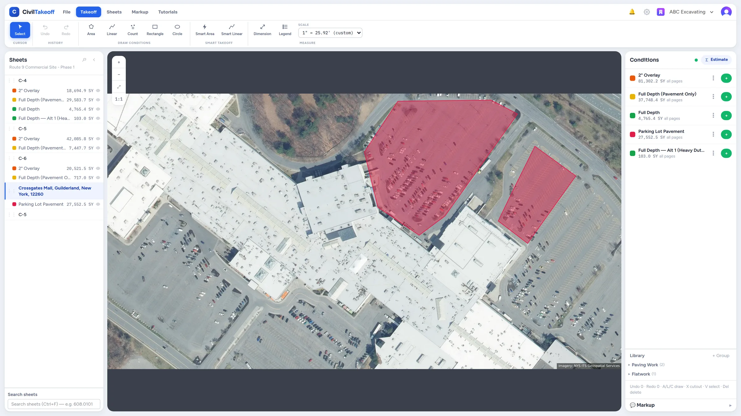
Start with the address you already have
An early paving or sitework request may arrive with a location and a description of the work. Zip Takeoff gives you a place to start: find the site, frame the area you want to measure, and bring scaled imagery into your project.
Draw around visible pavement, measure a curb line, or place counts on features you can identify. The imagery's map coordinates provide the scale. You use the same manual area, length, and count tools available for PDF takeoff, so moving between an aerial and a plan sheet doesn't mean learning another measurement system.
Take the measurements through to material quantities
Attach material and bid items to your measurement groups, called conditions in the app. A visible pavement area can supply square yards of surface and, using a thickness and density you enter, a preliminary asphalt quantity. The photograph supplies the visible footprint; your scope and material inputs supply the rest.
These quantities can sit alongside PDF takeoff in the same project. Keep the source clear with a name such as “Parking lot from aerial,” review the totals in Zip Takeoff, and export to Excel when you need a file. You don't need a separate workbook just to turn the measured area into material units.
Example: an early parking-lot paving budget
Suppose an owner asks for a preliminary budget for a parking lot before issuing drawings. Measure the visible pavement, exclude landscaped islands from the area, and group the portions being considered for different work. Use the owner's proposed scope and your stated material assumptions to prepare the early quantities.
When plans or site information arrive, compare them with the aerial takeoff and update the measurements and inputs. Keep optional work in a separate Alternate group so the Base Bid and each option remain clear. The preliminary takeoff gives you something to develop as the scope becomes more certain.
Free satellite measurements, with room for a real project
Satellite takeoff is included on Free with 1 estimator, 10 projects, and 5 GB of plan storage. Original PDFs and satellite images count toward that storage. You can measure, attach items, and export quantities without a credit card or a trial deadline.
In-app satellite walkthroughs show you how to bring in an image and measure it. Zip Takeoff is built by a working estimator, with early site measurements connected to the same item quantities and bid options you'll use when the plans arrive.
Use the image for what it can show
Aerial imagery may predate site changes, and trees, buildings, or vehicles can hide features. It cannot establish pavement thickness, buried utilities, property boundaries, or current conditions. Treat these as preliminary quantities, check them against site information and issued plans, and use a survey where survey accuracy is required.